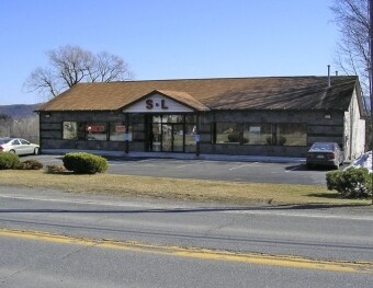
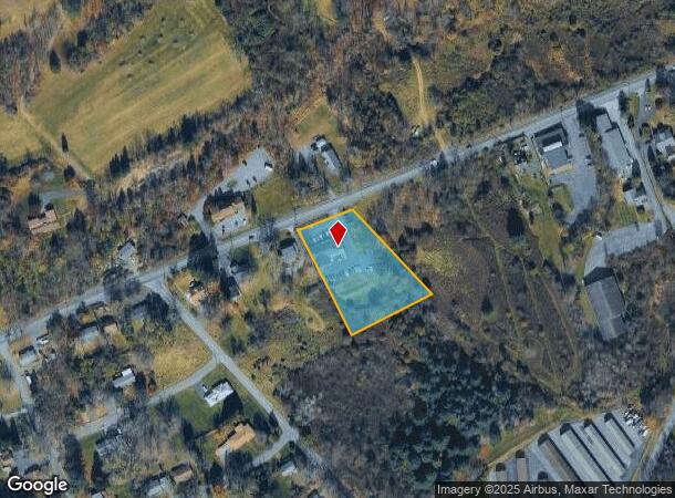
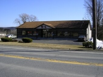
Property Record
2149 W Main St, Stroudsburg, PA 18360
NEARBY LISTINGS FOR SALE OR LEASE
Property Detail
2149 W Main St
17.11.1.40
S & L Hardware/Housewares
Storebuilding
Monroe
X
Pennsylvania
42089C0426E
1.39 AC
2025
Monroe County
2025
Philadelphia
301002
East Stroudsburg, PA
7,442 SF
DEMOGRAPHICS near 2149 W Main St
1 Mile
3 Mile
5 Mile
2024 Total Population
2,418
19,053
44,706
2029 Population
2,528
19,014
44,205
Pop Growth 2024-2029
+ 4.55%
(0.20%)
(1.12%)
Average Age
45
44
42
2024 Total Households
1,005
7,612
16,671
HH Growth 2024-2029
+ 5.07%
(0.14%)
(0.94%)
Median Household Inc
$65,625
$65,156
$73,208
Avg Household Size
2.30
2.40
2.50
2024 Avg HH Vehicles
2.00
2.00
2.00
Median Home Value
$216,363
$251,582
$242,413
Median Year Built
1987
1979
1980
Nearby Places
Map Layers
Map Styles
 Street
 Aerial
- Restaurants
- Banks
- Shops
- Fitness
- Groceries
PUBLIC TRANSPORTATION
AIRPORT
Lehigh Valley International
DRIVE
WALK
Distance
Lehigh Valley International
44 min
29.3 mi
Freight Ports
Maher Terminal
DRIVE
WALK
Distance
Maher Terminal
92 min
72.7 mi
SALE & LEASE HISTORY
LISTING DATE
SALE/LEASE

Sep 24, 2016
For Sale
Nearby Properties
Address
Land Use
TOTAL SIZE
Lot Size
Zoning
Address
Land Use
TOTAL SIZE
Lot Size
Zoning
382,084 SF
43.31 AC
C-2
Address
Land Use
TOTAL SIZE
Lot Size
Zoning
265,064 SF
107.97 AC
R-1
Address
Land Use
TOTAL SIZE
Lot Size
Zoning
96,316 SF
34.38 AC
C-2
Address
Land Use
TOTAL SIZE
Lot Size
Zoning
48,796 SF
5.69 AC
C-1A
Address
Land Use
TOTAL SIZE
Lot Size
Zoning
85,940 SF
16.19 AC
C-2
Address
Land Use
TOTAL SIZE
Lot Size
Zoning
64,736 SF
1.53 AC
MU-B
Address
Land Use
TOTAL SIZE
Lot Size
Zoning
104,753 SF
24 AC
C-2
Address
Land Use
TOTAL SIZE
Lot Size
Zoning
39,779 SF
27.15 AC
C
Address
Land Use
TOTAL SIZE
Lot Size
Zoning
70,939 SF
2.33 AC
C-2
Address
Land Use
TOTAL SIZE
Lot Size
Zoning
113,052 SF
1.56 AC
C-2
Address
Land Use
TOTAL SIZE
Lot Size
Zoning
13,050 SF
5.96 AC
C-2
Address
Land Use
TOTAL SIZE
Lot Size
Zoning
49,848 SF
5.15 AC
C-2
Address
Land Use
TOTAL SIZE
Lot Size
Zoning
468,747 SF
Address
Land Use
TOTAL SIZE
Lot Size
Zoning
179,576 SF
1.76 AC
C-2
Address
Land Use
TOTAL SIZE
Lot Size
Zoning
52,322 SF
2.93 AC
C-2
Address
Land Use
TOTAL SIZE
Lot Size
Zoning
9,916 SF
9.63 AC
R-3
Address
Land Use
TOTAL SIZE
Lot Size
Zoning
68,039 SF
5.49 AC
R-1
Address
Land Use
TOTAL SIZE
Lot Size
Zoning
124,559 SF
8.53 AC
R-1
Address
Land Use
TOTAL SIZE
Lot Size
Zoning
115,422 SF
9.27 AC
R-1
Address
Land Use
TOTAL SIZE
Lot Size
Zoning
39,879 SF
2.91 AC
C-2
Address
Land Use
TOTAL SIZE
Lot Size
Zoning
8,554 SF
194 AC
C-3
Address
Land Use
TOTAL SIZE
Lot Size
Zoning
39,635 SF
4.78 AC
C-2
Address
Land Use
TOTAL SIZE
Lot Size
Zoning
32,166 SF
3.16 AC
C-2
Address
Land Use
TOTAL SIZE
Lot Size
Zoning
53,580 SF
2.32 AC
C-2
Address
Land Use
TOTAL SIZE
Lot Size
Zoning
94,066 SF
36.26 AC
R-1
Address
Land Use
TOTAL SIZE
Lot Size
Zoning
10,988 SF
10 AC
R1
Address
Land Use
TOTAL SIZE
Lot Size
Zoning
32,350 SF
7.77 AC
R-3
Address
Land Use
TOTAL SIZE
Lot Size
Zoning
51,976 SF
1.52 AC
C-2
Address
Land Use
TOTAL SIZE
Lot Size
Zoning
49,255 SF
2.89 AC
C-2
Address
Land Use
TOTAL SIZE
Lot Size
Zoning
27,360 SF
4.52 AC
C-2
The World's #1 Commercial Real Estate Marketplace
Connect with us
© 2025 CoStar Group
The information above has been obtained from sources believed reliable. While we do not doubt its accuracy we have not verified it and make no guarantee, warranty or representation about it. It is your responsibility to independently confirm its accuracy and completeness. Any projections, opinions, assumptions, or estimates used are for example only and do not represent the current or future performance of the property. The value of this transaction to you depends on tax and other factors which should be evaluated by your tax, financial, and legal advisors. You and your advisors should conduct a careful, independent investigation of the property to determine to your satisfaction the suitability of the property for your needs.